


If you stay
in Gauteng, Mpumalanga, Free State or North-west provens your live is depending
on the Vaal River. The entire Gauteng and about 13 other municipalities get
there drinking water from the Vaal Dam. That gets its water from the Vaal River
and when the Vaal River gets dry the Dam get additional water from the Lesotho
Highlands Water Scheme. Rand Water with draw 4 320 Mℓ/d in a day and 95% of
that is for Human consumption according to their web page.
The Vaal
River is 1120Km long and have its origin at Breyten according to Wikipedia. So I decide to go and see this
starting point of the Vaal River during my December 2017 holiday.
On 19
December I took my family on a tour of the Highveld to the origin of the Vaal
Rive Google maps show it clear and it is easy to get this nature wonder.
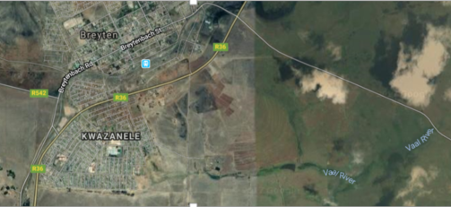
Lets Zoom in

The
Green aria on this map shows the wetland
where everything is supposed to start


Indeed a nice polluted wetland with the
informal/formal settlement next to it. The first flowing water is just north of
the little bridge at the bottom of the wetland. Yes the first bridge over the
Vaal River how romantic I found the place.
Sadly the water coming out of the wetland had an Olli
substins on it. Disappointed I start to drive back on the gravel road that
brings you to the start of the Vaal river. Just to notice a very strong stream of
water coming down the hill. Immediately I thought there must be a strong spring
that supplying the Vaal River. I thought that I was at the wrong place. I start to
follow this stream of water and to my Excitement fond the strong spring that
starts the Vaal River. It is one of the strongest fountains I have ever seen. It
is so clear on Google how could I miss it this strong spring must have been
there for many years if it is so clear on Google maps. See my Photos of this
strong spring and the map below.

The Green marked surrounding is
the wetland that feeds water into the first pool of water next to the bridge
indicated by the Yellow arrow. The red arrow shows the stronger spring of raw sewage
On the left of the picture is the town and informal/formal settlement. In the
right-hand top corner of the picture is the Surge water processing plant. This is a huge crime scene towards humanity
and environmental disaster.
Raw sewage at the start of the Vaal River

Raw sewage at the start of the Vaal River

Do not tell me the workers of the sewage works cannot see this every time they drive to their work place on this road

And still we drink 4 320 Million lieters of this water a
day!!!
Why do we
have a sewage works right next to a place that should be declared as a National
Heritage site?
How many more of these raw sewage works holds
a polluting risk to the water we drink from
the Vaal River?
On Google I
have followed the Vaal river and some of the side streams like the Vaal River at
Leandra and find 8 more potentially dangerous water works that could threaten
or already pollute the drinking water of the Vaal dam. Who monitor these
dangers on a day to day base and bring pollute to a stop in a save time?
As a
proud South African I demand answers and solutions to this problems from the
authorities . I have the right to clean drinking water not clean sewage water.

